
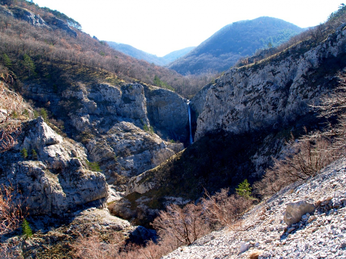
The Waterfall
The Rosandra stream rises beyond the present-day state border, in the Municipality of Hrpelje-Kozina, east of Bottazzo-Botač, and from here to the first waterfall it has the generic name Potok (stream, torrent). The etymology of the name Rosandra-Glinščica is very uncertain, but it seems to derive from the noun klin (wedge), klinčica meaning the wedge of the stream in the narrow limestone space of the mountains bordering that part of the valley; the Rosandra-Glinščica stream, over its short course, has a waterfall: a 35-metre drop that carries water into an erosion basin and forms a small lake whose colours range from green to blue. This is the first of a series of twenty-one pools that follow one another in the short space between the waterfall and the hamlet of Bagnoli Superiore-Gornji konec.
Roman aqueduct
It was the Romans who built the aqueduct in the 2nd century B.C., to bring water from the springs of Rosandra-Glinščica and Crogole-Kroglje and Dolina to the city of Trieste. It was a simple construction consisting of a stone base and two side walls, connected and covered by a vault. It was 160 cm deep and 55 cm wide, and some 17 kilometres long, allowing a flow of 5,800 cubic metres of water per day to the city of Trieste. Some sections have been preserved until today and the remains can be seen at the entrance to the valley (CAI path no. 1).
The ancient little church of S. Maria di Siaris - sv. Marija na Pečah
Harmoniously blended into the wilderness against a rocky backdrop, the church stands on a steep cliff to the left of the Rosandra-Glinščica stream. A document from 1367 mentions it as a destination for penitent pilgrims, stating that anyone who blasphemed in public or used vulgar language had to go barefoot to the Church of S. Maria di Siaris to ask the Virgin for forgiveness.
The place is particularly charming and the view is unique: from the rocky ridges one has a view of the valley and the entire surrounding area and the Rosandra-Glinščica stream below.
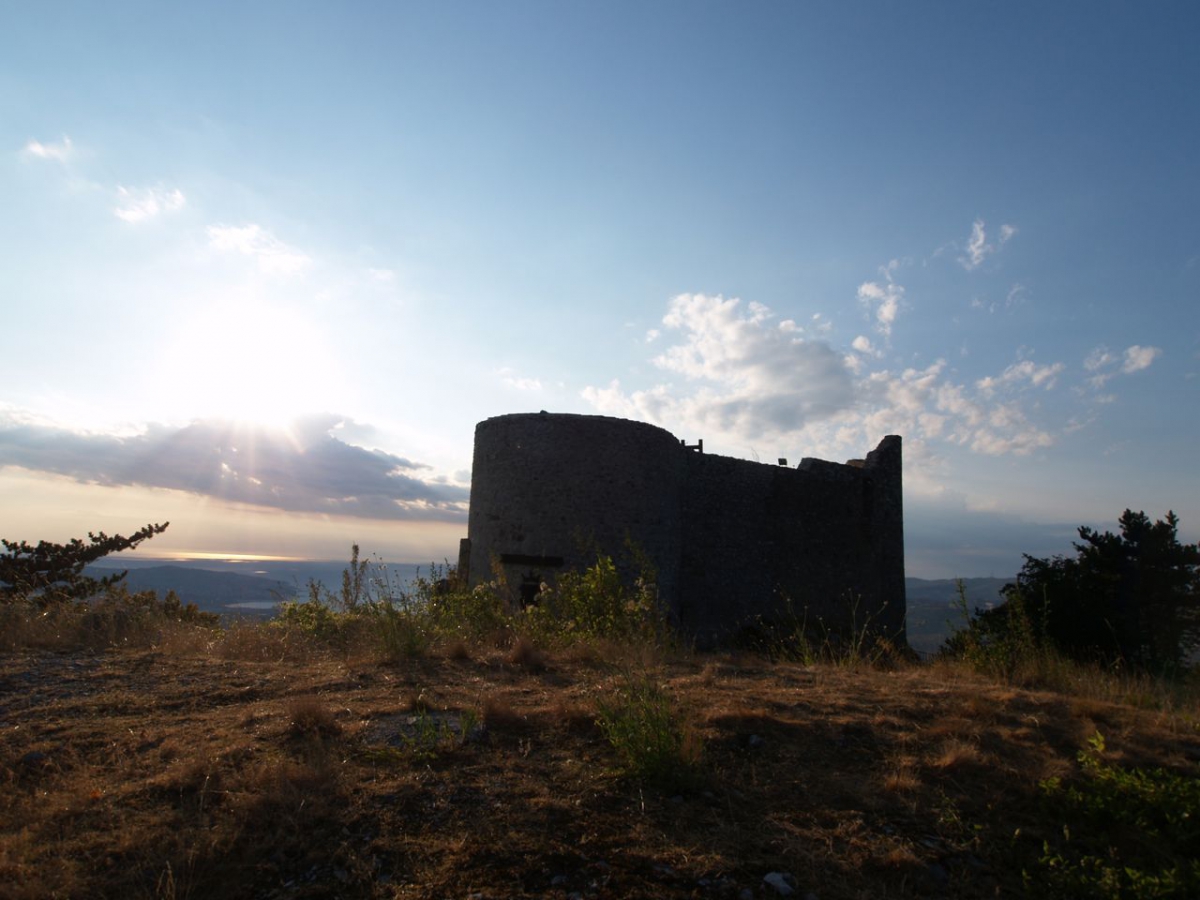
Il Castello di Moccò (Moccò Castle) - Muhov grad
Built in a strategic position on Moccò hill (241 m), it was an advanced defence of the people of Trieste for centuries. The oldest document mentioning the castle dates back to 1190. It was used as a tower from where the salt route from the sea to Carniola was controlled. After its destruction in 1511, a new castle was built just below it in the 17th century, reusing the stones of the old one. It too had a turbulent life, and in the late 19th century it became a tavern and hotel. The square tower remained intact until the last days of the Second World War when it was blown up by German troops; only minimal traces now remain. From where the Moccò-Muhov grad Castle once stood, the view over the valley and the Gulf of Trieste is wonderful.
The Castle and the Cave of San Servolo - Socerb
The castle of San Servolo-Socerb, now on Slovenian territory, is a place which has been inhabited since prehistoric times, whose solid, partly ruined walls and tower can be seen from the village of Dolina.
It is these ruins, set against the peace that inspires the whole area, that remind us that for centuries this was one of the stops made by pilgrims on their way to Jerusalem: many rock engravings, along the paths and especially in the San Servolo-Socerb hollow, bear witness to this.
About three hundred metres northeast of the historic castle is the cave of St Servolo-Socerb, the only underground church in Slovenia. The cave is about 48 metres deep and 50 metres long, and has two gated entrances.
The cave is symbolic of the legend of St Servolo-Socerb. In the 3rd century, it is said to have served as a refuge for the 12-year-old Christian boy Servulus, who returned to the city after twenty-one months of being a hermit with miraculous powers of healing and exorcism.
The Mills
Along the Rosandra river and its tributaries from St. Anton in Bosco-Boršt to Domio-Domjo there were 32 mills, which were used by the people of Dolina, but also by the inhabitants of Trieste up to the Karst plateau. The millers were skilled at carving stone for the wheels, while their wives were in charge of trading the flour that was taken by donkey to the town and further afield.
Technological progress caused the business to stop in the 1970s. Today, the remains of four mills can be seen or guessed at in the area of Bottazzo-Botač, one below Draga and four before the settlement of Upper Bagnoli-Gornji Konec.

Get in touch